
We’re upgrading the gateway into New Brighton, including the Pages Road Bridge, which is key to improving the emergency evacuation of the area.
Sign up to our Pages Road Bridge renewal newsletter

Our plans include:
- Replacing the Pages Road bridge across the Ōtākaro-Avon River.
- Replacing the roundabout at Pages Road, Hawke Street and Seaview Road with a new intersection and traffic lights.
- Increasing Pages Road westbound to two lanes.
- Upgrading underground utilities and three waters infrastructure.
- Other intersection modifications, including pedestrian crossings and parking changes.
The new bridge and road will be more resilient to future earthquakes and the effects of climate change. It will be designed to improve access for everyone, from truck and car drivers to cyclists and dog walkers, and everyone in between. This project will enable large volumes of traffic to exit New Brighton and the surrounding suburbs during planned and unplanned events.
The work to upgrade Pages Road and build the new bridge will require changes to eight nearby roads. These are Hawke Street, Owles Terrace, Hardy Street, Seaview Road, New Brighton Road, Rawson Street, Pratt Street and Keyes Road.
Fly through the design
The existing Pages Road Bridge, which was built in 1931 and is the main route across the Ōtākaro-Avon River into New Brighton, suffered significant earthquake damage in 2011.
It is currently operating at about 15% of the new building standards, so it is earthquake-prone.
During the earthquakes, Pages Road buckled and dropped in places, affecting drainage. Short-term emergency repairs have served their purpose, and it’s now time for a new bridge and for the road to be upgraded and improved.
The replacement bridge and approach roads will be more resilient and have increased capacity in emergency evacuations. They will be built at a higher level, allowing for sea level rise and incorporating future stop banks along the Ōtākaro Avon River.
Work in the surrounding area will also provide more walking and cycling connectivity to New Brighton. The current roundabout area will also become a small park featuring the existing palm tree, providing a community facility.
The new bridge and traffic lights will be slightly north of the current position. This will allow the existing bridge to be used while construction is underway.
These changes will make it safer to get in and out of New Brighton. And of course, we want it all to look great too, so landscaping is an important part of the project.
We ran early engagement and public consultation throughout 2023. A hearings panel met in early 2024 to consider submissions and made recommendations. These were approved by the Council in August 2024, and changes were made to the design to reflect feedback.
Hearings Panel and Council decision documents
- Hearing Panel Agenda - 4 April 2024(external link)
- Hearings Panel Minutes - 4 April 2024(external link)
- Council Agenda - 7 August 2024(external link)
- Council Minutes - 4 August 2024(external link)
You can also watch the Hearings Panel report to the Council(external link).
Read more about our consultation and the decision-making process(external link).
The Council has allocated funding through our 2024-2034 Long Term Plan for the project. The surrounding streets renewal work will be subject to funding as part of the next long term plan development.
A funding subsidy application to New Zealand Transport Agency Waka Kotahi was approved in August 2025, with the central government committing to $38.5 million in funding towards the project. The central government funding will come from the National Land Transport Fund (NLTF).
Procurement for the detailed design and construction contract is underway. Once a contract has been awarded later this year, the detailed design will begin. The sensitive nature of the surrounding area and proximity to the Avon River mean it’s likely that gaining consents will take time.
The project is likely to be built in two phases, starting with Pages Road, the new bridge, Seaview Road and Hawke Street intersection, the new pocket park and intersection improvements. The full renewal of the nearby roads will be completed at a later date when additional funding is available.
We expect the design to be complete and consents granted, ready for us to start construction, in mid 2028. There is an opportunity to start construction earlier if consents are approved earlier than anticipated. The first phase is likely to take between 18 and 24 months to build.
The new bridge and traffic lights will be slightly north of the current position, so the existing bridge can be used while construction is underway.
Pages Road Bridge Renewal project details
The new bridge will be slightly north of the existing one, allowing the current bridge to stay open while the new bridge is being built, which could take up to two years.
When the new bridge is open, the old one will be demolished.
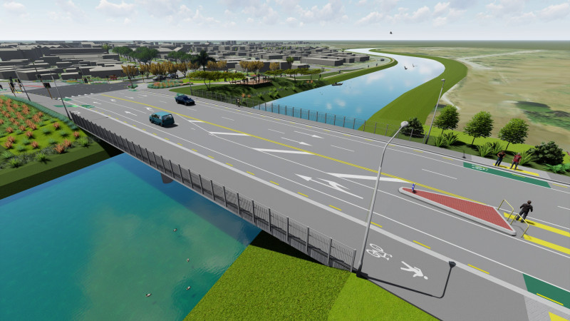
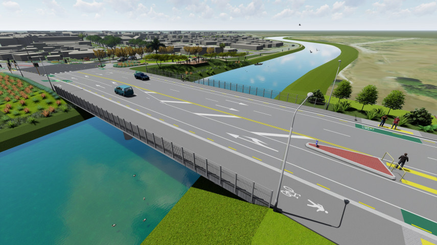
Artist impression only - detail to be confirmed.
In addition to the new bridge, we're renewing Pages Road between Anzac Drive and the new bridge to create a gateway that celebrates New Brighton.
We’re planning one lane eastbound into New Brighton and two lanes westbound out of New Brighton. This will significantly improve the traffic flow after large events and allow everyone to leave quickly in an emergency evacuation.
We’ll remove the bus stops halfway between Anzac Drive and the bridge, but the bus stops nearest Anzac Drive will remain. We're including on-road cycle lanes on each side of Pages Road and a new footpath on the south side of Pages Road, as well as a four-metre-wide path for walking and cycling along the north edge of the road.
Two pedestrian islands – one just west of the bridge and one nearer to Anzac Drive – will make it safer for people to cross Pages Road.
Pages Road will be lined with native coastal forest planting. The mixed heights of plants will allow views through to the wetlands. A new centre median down the length of Pages Road between Anzac Drive and the bridge will be planted with pohutakawa trees.
The roundabout at the New Brighton end of the bridge is no longer efficient or safe for all road users. We plan to remove the roundabout and create a signalised T-intersection at the Pages Road, Seaview Road and Hawke Street intersection. This will make the intersection safer for everyone, including pedestrians and cyclists, and far more efficient – especially during an emergency evacuation from the coast.
To do this, New Brighton Road and Owles Terrace will not connect to the new intersection. While it might seem counterintuitive, traffic modelling shows that closing these two roads in the intersection, along with the other road improvements, will take approximately 40 minutes off the emergency evacuation time for the whole area.
Vehicles travelling from Owles Terrace will instead travel to Hardy Street and Seaview Road to access the bridge. Vehicles travelling from New Brighton Road will use Rawson Street and Keyes Road to access New Brighton.

We know that New Brighton needs to be able to evacuate quickly if there’s an emergency, so a key aspect of this project has been to develop a road layout that is more efficient in an emergency evacuation.
We’ve used traffic modelling to test different road layouts and help us to determine the most efficient road layout for an evacuation. Many different road layouts were tested by the traffic model, these included: leaving the road layout as it is currently, using give way signs at the intersection versus traffic lights, one lane westbound out of New Brighton versus two lanes out, and connecting New Brighton Road and Owles Terrace to the intersection.
Our planned layout will make it approximately 40 minutes faster for the area to evacuate compared to the current road layout.
If you would like to find out how to be prepared for an emergency, head to our Civil Defence page.
We know that many people love the palm tree in the middle of the roundabout, and we do too. We plan to keep it as a feature in a new pocket park. There will be landscaping around the palm tree, and paths for walking and cycling.
To celebrate this area as the gateway to New Brighton, space has been reserved for artworks on either side of Pages Road, east of the bridge. The artwork will be developed in collaboration with mana whenua during the detailed design of the project, leading into construction. There is also an opportunity for artwork to be incorporated into other built and landscape elements, such as the bridge handrails and paving patterns.

Artist impression only - detail to be confirmed
The surrounding streets' improvement work will be subject to funding as part of developing the next long term plan.
The work to upgrade Pages Road and build the new bridge requires changes to eight nearby roads.
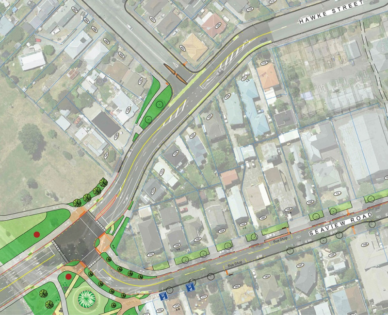
Hawke Street
We plan to resurface the road and align it with the new intersection, including changing the line markings to create the two lanes out of New Brighton. The on-road cycle lane will continue just past the Keyes Road intersection. We’ll need to include some no-stopping restrictions to do this.
In phase 1 of the delivery, work on Hawke Street will focus on features to align it with the new T-intersection and new bridge. Street renewal work, including resurfacing, will be included in phase 2 and is subject to funding through the long term plan.
Owles Terrace
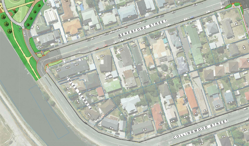
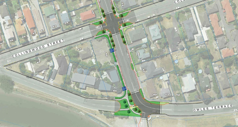
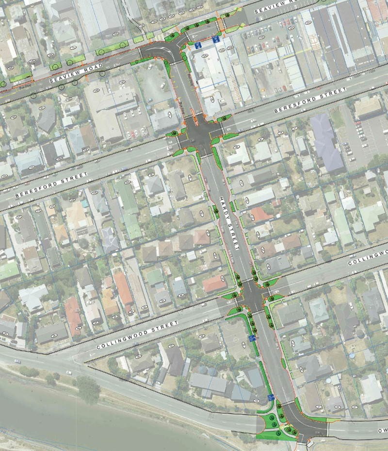
We plan to close Owles Terrace at both Beresford Street and Hardy Street to improve road safety, make emergency evacuation more efficient, and provide space for future flood protection measures along the river.
Owles Terrace residents will be able to access their properties from Beresford and Collingwood Streets.
A new shared accessway from the Owles Terrace and Beresford Street corner will provide walking and cycling access through to the new pocket park and the new bridge.
Hardy Street
To accommodate the increased traffic, Hardy Street will need to be upgraded. We will improve the whole street including a new surface, replacing the deep-dish guttering with kerbs and adding in street trees and low planting.
Stop and give-way priorities will change at three of the intersections along Hardy Street to improve north-south traffic flow.
All intersections along Hardy Street will have raised safety platforms to slow traffic to a 30km/h speed limit. This will make it way safer for everyone, including children and families getting to Nova Montessori School on the corner of Hardy Street, near Owles Terrace.
Seaview Road
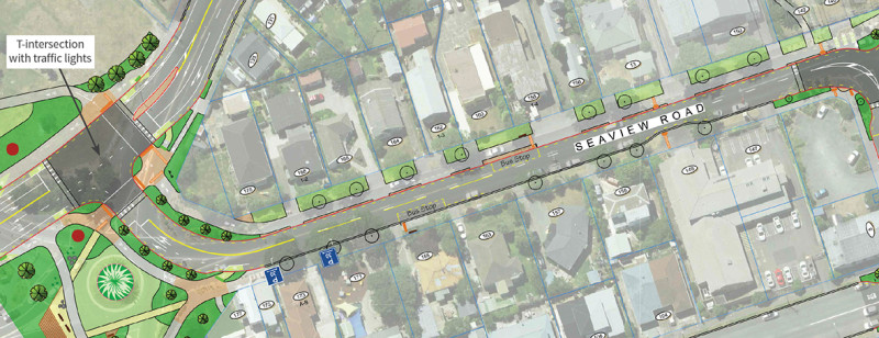
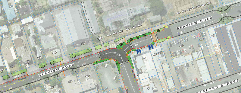
Seaview Road will also be resurfaced and the four-metre-wide path along Pages Road will continue as a three-metre-wide path down the north side of Seaview Road to provide a cycling and walking route towards Brighton Mall.
We’ll be moving the bus stop on the north side of Seaview Road slightly east of the current position. The bus stop on the south side will stay where it is.
To keep the well-established trees and incorporate the shared path on Seaview Road we’ll need to make the northern side of the road a no-stopping area from Hawke Street to Hardy Street.
New Brighton Road and Rawson Street
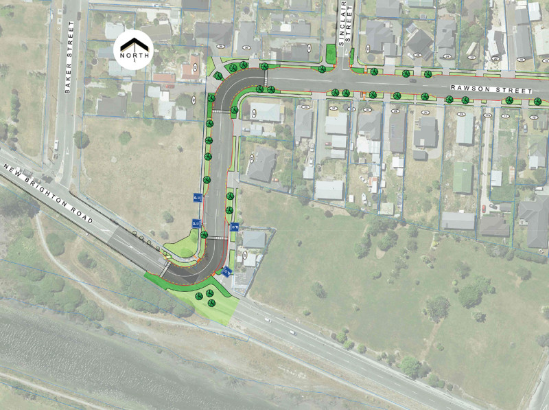
New Brighton Road will be closed to vehicles between Rawson Street and Pages Road. This makes the new Pages Road intersection safer, emergency evacuation more efficient and allows space for future flood protection work. Pedestrians and cyclists will still have access through this section of New Brighton Road.
As the primary route to New Brighton Road, Rawson Street will be upgraded with intersection improvements and raised safety platforms at the two bends in the road to slow traffic around these tight corners. We plan to resurface the road, replace the deep-dish guttering with kerb, introduce street trees, add P10 parking and landscaping outside the Beachcomber Dairy.
In phase 1, work on Rawson Street will focus on rerouting traffic to join Keyes Road. The street renewal work, including road resurfacing and raised safety platforms, will be included in phase 2 and be subject to future long term plan funding.
Pratt Street
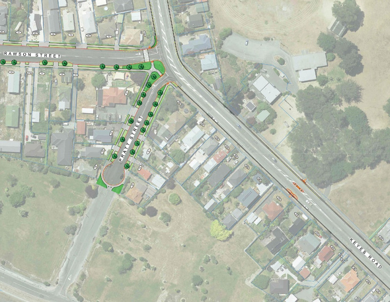
Pratt Street will become a cul-de-sac and will be upgraded, including a new road surface and street trees and low planting.
In phase 1, work on Pratt Street will focus on the installation of the cul-de-sac. The street renewal work, including road resurfacing, will be included in phase 2 and be subject to future long term plan funding.
Keyes Road
We plan to install a new pedestrian crossing on Keyes Road to make it safer for people to come and go from Rawhiti Domain.
The intersection between Keyes Road, Pratt Street and Rawson Street will be improved to make it safer.
Overview plan [PDF, 10 MB]